Introduction
Urban landscapes in India are today emerging as a set of disparate conditions spreading across the country irrespective of the city boundaries. These conditions such as transportation facilities like the railways, road networks, flyovers and high ways form the basis of contemporary Indian urbanism. They mark the nature of city’s progress and observe the need of the public. However, there are vast amount of urban spaces which appear in various scales, intensities and forms which are abandoned due to such kind of urbanism. Although there have been a few initiatives in some cities in India too, to revive the derelict pockets within the city and turn the urban “negatives” into “positives”.

Anti-space, Border Zones, are usually chaotic, since they are comprised of the remnants of other uses. But these could be used to knit together the fabric of a city at a crucial border zone. Residual areas, buffer zones, vacant land do separate one zone of building from the other, but they also connect the enclaves and afford opportunities of a range of actions. These interstitial spaces can act as potential spaces for urban restructuring .They can act as public spaces which today occupy crucial components of the city, both in terms of the physical as well as social function they serve. Edges, while generally separating and isolating areas, could conversely be seen uniting space between two areas. The space could be designed to give a sense of ownership of it to the community, it could be designed to reunify areas of the city that have been severed by urban renewal. Any flyover must not present a significant visual obstruction that effectively cuts the community, and similarly, must eliminate undesirable residual spaces. There are numerous examples that celebrate design and engineering, creating contemporary urban sculptures that add positively to sense of place, rather than detract from it.
CASE STUDIES:
Ahmedabad:
Ahmedabad has a number of bridges and flyovers to increase the connectivity within the city. While the bridges are planned primarily for improving vehicular flows, the spaces under the bridge structures are left unplanned, ending up as haphazard parking, encroachments and garbage dumps. Such disused spaces degrade the surrounding areas and act as a divide in neighbourhoods. However, the civic body finally seems to be waking up to the gross disuse of property worth lakhs, though it has taken the Ahmedabad Municipal Corporation (AMC) a whole year to plan and finalize the design for space utilization at one such over bridge. A few options have been shortlisted like setting up a vegetable market, a mini food court, rickshaw parking space and also a small library.

AMC's bridges department had carried out a survey to identify flyovers which have adequate space that can be utilised for public use. Of the nine, survey identified five over bridges for development.-Soni Ni Chaali over bridge, Shahibaug railway over bridge, Jivraj Mehta Bridge, Thakkarnagar and Chanakyapuri bridges. HCP is engaged in this initiative by Ahmedabad Municipal Corporation (AMC) towards improving the urban environment and aims to humanize these transport infrastructures and reclaim the underutilized spaces under bridges and flyovers. The proposed uses under these bridges are context specific and based on the detailed study of the adjacent neighbourhoods, on-site documentation of the bridges and general use and activity patterns.
AMC had proposed a flyover at the IIM junction due to the prolonged traffic congestion at this intersection and HCP was awarded the project for design and project management which includes city wide traffic pattern and traffic count surveys of the intersection, which lead to the finalization of the alignment of the flyover.

This project goes beyond the conventional flyover project. It includes comprehensive development of 920m length that includes the flyover (504 m), the spaces under the flyover and the complete right-of-way width. It is a four lane flyover having a total width of 13.5 m. The public space under the flyover constitutes of 1340 sq. m. of built up area. The construction sequencing of the flyover is also designed to minimize the impacts on the surroundings and on the traffic and BRTS operation along 132ft road during construction.
Mumbai:
The JJ flyover, runs from the Crawford Market area all the way to Byculla, jumping over some of the densest and most frantic neighbourhoods of Mumbai. It is a mess of traffic above and a mess of traffic below. All accommodations are made for the car and truck, while pedestrians are left to fend for themselves. While the flyover features prominently on all maps of Mumbai, the space beneath it is a curiously overlooked space. Open spaces below several flyovers across the city have been encroached. Still, a host of activities happen here nonetheless. In the mornings, informal markets spring up selling everything from chai to chickens, fish to fruit. Street children play games; mothers wash clothing, cook food and sell small goods in the tiny leftover spaces of intersections and traffic medians. In the evening, food stalls set up shop and labourers gather to share food and drink, some eventually falling asleep in the vacated parking spaces.

Every day, in thought and action, the inhabitants manage to bring together what was disjointed by modernist zone planning: a tremendous act of place making. The residual strips interpreted as public space offer kinds of encounters between different groups of inhabitants. Residual urban space can become a catalyst for transformation that would otherwise remain largely inaccessible. The space could be designed to give a sense of ownership of it to the community, it could be designed to reunify areas of the city that have been severed by urban renewal.

At a time when preserving an open space in the city is becoming next to impossible, the residents of Matunga and Dadar have come up with an innovative proposal to keep the open space below the Ambedkar Road flyover free from encroachments and illegally parked vehicles. Residents have submitted their proposal to the Mumbai Metropolitan Regional Development Authority (MMRDA) elaborating the usage of the open space beneath the flyover. Imagine a basketball court, a museum, a joggers’ track and an amphitheatre — all below one of Mumbai’s most congested flyovers.
Proposal
 The design submitted to MMRDA speaks for itself. It clearly shows exactly where local residents want to set up a small museum displaying old photos of the city. Apart from this, the plan also includes an amphitheater, a skating path, a joggers’ track, seating arrangements for people, small flower garden and even a basketball court. Residents also want to create seating arrangements around the pillars of the flyover in addition to creating a circular track for people to walk or jog on.
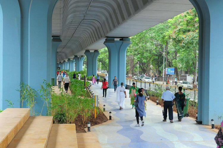 These amenities will be spread out at regular intervals under the flyover, providing enough space for people to relax. “We have submitted different designs. The MMRDA will hopefully approve one of them, depending on what they think is feasible,” said a resident.
 The stretch identified is beneath the Ambedkar Road (officially known as the Tulpule flyover) between King’s Circle and Dadar, which is nearly 1 km long. In a bid to prevent encroachment by illegally parked cars and beggars, residents first approached the BMC and local police to barricade the entrance.
Preventive measures have led to a lot of space being cleared. The difference is clearly seen beneath the flyover in the mornings or evenings. Women and senior citizens take their evening walks here while children cycle and play. The letter submitted by the locals to Mayor Sunil Prabhu and BMC officials states that they are interested in developing it by themselves, for which they require permission from the civic body. Sources in the MMRDA claim that they plan to beautify the space below several flyovers by creating gardens and artificial structures in order to prevent encroachments. Clearly, the residents of Matunga and Dadar have shown the way.
Chennai
The Chennai Corporation has planned to turn untidy, unused areas beneath all its flyovers into vibrant public spaces. Accepting many of the proposals made by a consultant City Connect, an NGO, for optimum use of space beneath five flyovers, the civic body has decided to cover all the flyovers in the city under the beautification scheme. Beautification of spaces beneath flyovers will not consume any additional road space. The focus would be on giving pedestrians more access to this space. Residents of the city may soon have more recreation spaces at an unlikely venue – beneath flyovers.
Flyovers to be covered in the first phase are those on Royapettah High Road, Dr. Radhakrishnan Road near The Music Academy, T.T.K. Road in Alwarpet, Cenotaph Road and Sardar Patel Road. Each of the flyovers will display local flavours of Chennai. The proposal for the R.K. Salai flyover will depict the city's identity as a center for music. The Pantheon Road flyover will bear an archaeological flavour and the Sardar Patel Road flyover may display elements of education, due to its proximity to reputable institutions.

Landscaping will aid in making encroachments impossible. A sunken gallery space would be created by excavating earth beneath the R.K. Salai flyover. Plans to install panels with LED fittings for lighting and solar pipes, and landscaping of an 80 meter-stretch, promise to make the area visually appealing. The solar pipes function by total internal reflection and will provide natural lighting in the landscaped areas. U-turns and zebra crossings will be demarcated with inputs from traffic police. Spaces would be created for an ambulance and police vehicles. Renting bicycles stands for tourists who wish to go for a ride would be setup. Public conveniences will also come up. All these proposals would enliven these spaces and add life to different localities.
Discussion
Observation of the case studies strongly manifest of the opportunities and possibilities that the disregarded leftover spaces specifically under the flyovers offers. All case studies though different in location and community background, suggest of future activities and uses that could be considered in designing spaces under the flyovers if conditions permit. Some similarities of activities and uses were found which suggest that in order to attract users from surrounding communities the leftover space may need to have cafes, food stalls, leisure, recreational activities, business and occasional weekly activities. However, each area have their own unique characters, therefore activities that is distinctively unique to that area should be allowed to expand in order to create places with identity rather than homogenous spaces of traditional planning. This paper only focused on the activities that took place under the flyovers in few cities across the country, however in order to further understand these possibilities and opportunities that stimulates activities, research on the physical characteristics, and the more complex of community background need to be conducted.
But still the question remains as to why create a problem in order to solve it?
These spaces are universally unthought-of in the initial design process and are somehow pulled in by the planners as opportunities to enhance the urban cape later by somehow stitching it all together and hoping it to workout. But isn’t it all like creating a problem and then finding a solution to it.
What is the use of Evaluating, Designing, Imagining, Inventing and then again Re-evaluating, Re- designing, Re-imagining, Re-inventing, Re-inhabiting and Re-adapting the “once left over”?

Loop holes in the process
Decisions about growth patterns are made from two dimensional land-use plans, without considering the three dimensional relationships between buildings and spaces and without a real understanding of human behavior. In this all too common process, urban space is seldom even thought of as an exterior volume with properties of shape and scale and with connections to other spaces. Therefore what emerges in most environmental settings today is unshaped antispace. The approach should be between the design of site-specific buildings and that of the urban land-use plan with the concept of urbanism in urban design favoring the spatially connected public environment over the mere master planning of objects on the landscape. The approach calls for making figurative space out of the lost landscape.
Measures to be incorporated in the Planning process:
 For the creation of a new urban space or the re-design of an existing one, it is essential that proper attention is given to structuring the planning the design process and to involving all the necessary groups. A good process is certainly necessary to help define the parameters and requirements for the new urban space and as such it represents an essential precondition for a good design solution. The process itself, is not however sufficient to ensure a good outcome until the design proposals themselves provide the necessary quality and reflect the meanings and values of the local community in a way that they will come to identify with the new space and treat it as their own.
The process needs to analyse the spaces below an elevated highway visually, and explore the possibility of incorporating them into the surrounding communities through a comprehensive design that maximizes the functionality of the space while improving safety and the aesthetic qualities of the area. With a few small interventions and amenities, these patches of land could be completely transformed and that if given the chance, these slender patches of space would find a host of uses that would be constantly changing over time, responsive to collective need, present aspirations and seasonal calendar.

EMERGING QUESTIONS:
Should physical development of a parallel infrastructure network that effectively connect valued users and places while simultaneously bypassing non valued users and places within the city be permitted ?
Should insufficient investments be made to meet the infrastructural needs of the local population, as investment is targeted at privileged users in an effort to attract foreign capital investment, without even being sure of the Repercussions it would have in the coming years?
Are border zones and anti-space inevitable? , as the city scape is carved up and developed, or is there a completely different way to look at space?
Should such a move be the result of transportation improvements, rather than an outcome of a considered debate of our ‘sense of place’? Hence - How should we organize the planning process?

References:
Trancik Roger, Finding Lost Space: Theories of Urban Design, New York, Van Nostrand Reinhold, 1986
Jacobs, Jane, The Death and Life of Great American Cities, New York, Random House, 1961
Koolhaas, Rem, Junkspace, Cambridge, MIT Press, 2002.
Krier Rob, Urban Space,1991 ed., Academy Editions, London, UK., 1975
Corbusier Le, The Radiant City, The Orion Press, New York, 1933
Bacon, E.(1976) Design of Cities, New York: Penguin
Stanford Anderson, On Streets.
Robert Moses and the Modern City: The Transformation of New York
Gorden Cullen The Concise Townscape- 1961
Links:
http://www.hcp.co.in/project-details/61/69/274/amc-bridge-underspaces-development
http://www.slideshare.net/datarashok/spaces-below-flyovers#
http://archive.mid-day.com/news/2013/may/050513-residents-propose-amphitheatre-joggers-park-under-matunga-flyover.htm
Comments
Post a Comment